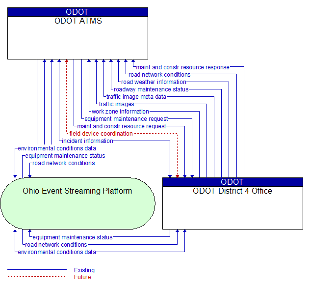
Interface: ODOT ATMS - ODOT District 4 Office
Information Flow Definitions
environmental conditions data (Existing) Selected Comm Solution
Current road conditions (e.g., surface temperature, subsurface temperature, moisture, icing, treatment status) and surface weather conditions (e.g., air temperature, wind speed, precipitation, visibility) as measured and reported by fixed and/or mobile environmental sensors and aggregated by the data collector. Attributes relating to the data collection (and aggregation) are also included.
equipment maintenance request (Existing) Selected Comm Solution
Identification of field equipment requiring repair and known information about the associated faults.
equipment maintenance status (Existing) Selected Comm Solution
Current status of field equipment maintenance actions.
field device coordination (Future) Selected Comm Solution
Coordination between operating centers that share control of the same field devices. This flow supports coordination to prevent conflicts and allow cooperative management of shared devices.
incident information (Existing) Selected Comm Solution
Notification of existence of incident and expected severity, location, time and nature of incident. As additional information is gathered and the incident evolves, updated incident information is provided. Incidents include any event that impacts transportation system operation ranging from routine incidents (e.g., disabled vehicle at the side of the road) through large–scale natural or human–caused disasters that involve loss of life, injuries, extensive property damage, and multi–jurisdictional response. This also includes special events, closures, and other planned events that may impact the transportation system.
maint and constr resource request (Existing) Selected Comm Solution
Request for road maintenance and construction resources that can be used in the diversion of traffic (cones, portable signs), clearance of a road hazard, repair of ancillary damage, or any other incident response. The request may poll for resource availability or request pre–staging, staging, or immediate dispatch of resources.
maint and constr resource response (Existing) Selected Comm Solution
Current status of maintenance and construction resources including availability and deployment status. General resource inventory information covering vehicles, equipment, materials, and people and specific resource deployment status may be included.
road network conditions (Existing) Selected Comm Solution
Current and forecasted traffic information, road and weather conditions, and other road network status. Either raw data, processed data, or some combination of both may be provided by this flow. Information on diversions and alternate routes, closures, and special traffic restrictions (lane/shoulder use, weight restrictions, width restrictions, HOV requirements) in effect is included.
road weather information (Existing) Selected Comm Solution
Road conditions and weather information that are made available by road maintenance operations to other transportation system operators.
roadway maintenance status (Existing) Selected Comm Solution
Summary of maintenance fleet operations affecting the road network. This includes the status of winter maintenance (snow plow schedule and current status).
traffic image meta data (Existing) Selected Comm Solution
Meta data that describes traffic images. Traffic images (video) are in another flow.
traffic images (Existing)
High fidelity, real–time traffic images suitable for surveillance monitoring by the operator or for use in machine vision applications. This flow includes the images. Meta data that describes the images is contained in another flow.
work zone information (Existing) Selected Comm Solution
Summary of maintenance and construction work zone activities affecting the road network including the nature of the maintenance or construction activity, location, impact to the roadway, expected time(s) and duration of impact, anticipated delays, alternate routes, and suggested speed limits. This information may be augmented with images that provide a visual indication of current work zone status and traffic impacts.