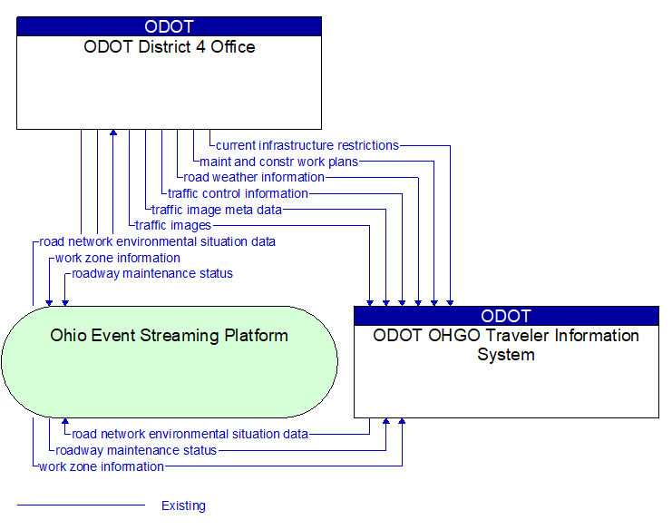
Interface: ODOT District 4 Office - ODOT OHGO Traveler Information System
Information Flow Definitions
current infrastructure restrictions (Existing) Selected Comm Solution
Restrictions levied on transportation asset usage based on infrastructure design, surveys, tests, or analyses. This includes standard facility design height, width, and weight restrictions, special restrictions such as spring weight restrictions, and temporary facility restrictions that are imposed during maintenance and construction.
maint and constr work plans (Existing) Selected Comm Solution
Future construction and maintenance work schedules and activities including anticipated closures with anticipated impact to the roadway, alternate routes, anticipated delays, closure times, and durations.
road network environmental situation data (Existing) Selected Comm Solution
Aggregated environmental situation data collected from vehicles and other sources for the road network. Aggregated information would include measured air temperature, exterior light status, wiper status, sun sensor status, rain sensor status, traction control status, ALB status, and other collected vehicle system status and sensor information for the region.
road weather information (Existing) Selected Comm Solution
Road conditions and weather information that are made available by road maintenance operations to other transportation system operators.
roadway maintenance status (Existing) Selected Comm Solution
Summary of maintenance fleet operations affecting the road network. This includes the status of winter maintenance (snow plow schedule and current status).
traffic control information (Existing) Selected Comm Solution
Represents the flow of traffic control and status information between centers. This is reporting only, not actual control. This specifically includes the current state of any demand management strategies that have been implemented.
traffic image meta data (Existing) Selected Comm Solution
Meta data that describes traffic images. Traffic images (video) are in another flow.
traffic images (Existing)
High fidelity, real–time traffic images suitable for surveillance monitoring by the operator or for use in machine vision applications. This flow includes the images. Meta data that describes the images is contained in another flow.
work zone information (Existing) Selected Comm Solution
Summary of maintenance and construction work zone activities affecting the road network including the nature of the maintenance or construction activity, location, impact to the roadway, expected time(s) and duration of impact, anticipated delays, alternate routes, and suggested speed limits. This information may be augmented with images that provide a visual indication of current work zone status and traffic impacts.